
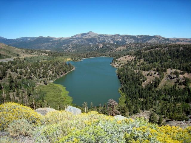
Map | View of Silver Lake from Hwy 88

Map | Dam at Castaic Lake off Hwy 88 Level being drawn down for dam repair

Map | Castaic Lake off Hwy 88 Level being drawn down for dam repair

Map | Castaic Lake off Hwy 88 Level being drawn down for dam repair

Map | Castaic Lake off Hwy 88 Level being drawn down for dam repair
Map | Red Lake near Carson Pass on Hwy 88

Map | East Fork Carson River - Hwy 89 east of Markleeville

Map | Entrance to Leviathan Mine near Monitor Pass on Hwy 89

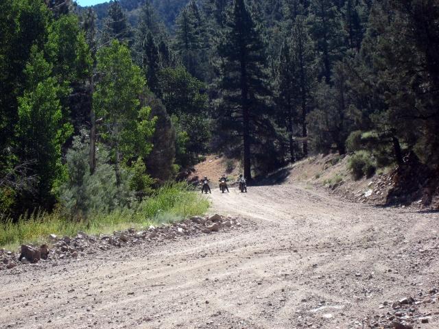
Map | Looking South from Leviathan Mine Rd norht of Hwy 89

Map | Looking South from Leviathan Mine Rd norht of Hwy 89

Map | Monitor Pass Hwy 89

Map | Looking south from east side of Monitor Pass

Map | Looking east from east side of Monitor Pass

Map | Looking southeast from east side of Monitor Pass

Map | Coming down the east side of Monitor Pass

Map | Coming down the east side of Monitor Pass

Map | My camp at Virginia Creek Settlement five miles south of Bridgeport on Hwy 395

Map | Patriotic Paint Job - the paint appreared to be an inch deep. Very impressive.

Map | Dog Days Riders/Supporters - Many didn't make this shoot.

Map | Masonic Rd east of Hwy 182 - Bridgeport Reservoir in background

Map | Masonic Rd at entrance to Chemung Mine

Map | Masonic Rd - at entrance to Chemung Mine waiting for Michele & Duc

Map | Masonic Rd - Michele & Duc arriving at entrance to Chemung Mine -

Map | Sharon and Wendy ready to explore Chemung Mine

Map | Chemung Mine

Map | Doug at Chemung Mine

Map | Wendy at Chemung Mine

Map | Chemung Mine

Map | Sharon at Chemung Mine

Map | Chemung Mine

Map | Chemung Mine

Map | Chemung Mine

Map | Chemung Mine

Map | View to the east from Chemung Mine

Map | Sharon & Wendy on Masonic Rd

Map | Sharon on Masonic Rd

Map | Sharon on Masonic Rd

Map | Masonic Rd near intersection with Bodie-Masonic Rd

Map | Masonic Rd near intersection with Bodie-Masonic Rd

Map | Masonic Rd near intersection with Bodie-Masonic Rd

Map | Masonic Rd near intersection with Bodie-Masonic Rd - Duc found some shade

Map | Masonic Rd near intersection with Bodie-Masonic Rd - Duc found some shade

Map | Masonic Rd near intersection with Bodie-Masonic Rd - Duc, Wendy, Sharon, Michele (l to r)

Map | Masonic Rd near intersection with Bodie-Masonic Rd

Map | Bodie-Masonic Rd - access road to equipment on top of mountain - didn't go there.

Map | Bodie-Masonic Rd

Map | Bodie-Masonic Rd

Map | Bodie-Masonic Rd

Map | Bodie-Masonic Rd

Map | Bodie-Masonic Rd with Bodie in distance - Sharon & Duc (l to r)

Map | Bodie-Masonic Rd - coming into Bodie from the north

Map | Sightseeing in Bodie - lunchtime Sharon, Duc, Wendy, Doug (l to r)

Map | Sightseeing in Bodie - lunchtime Duc, Wendy, Doug (l to r)

Map | Sightseeing in Bodie

Map | Sightseeing in Bodie, two-holer

Map | Sightseeing in Bodie

Map | Sightseeing in Bodie

Map | Sightseeing in Bodie

Map | Sightseeing in Bodie

Map | Sightseeing in Bodie

Map | Sightseeing in Bodie

Map | Sightseeing in Bodie

Map | Sightseeing in Bodie

Map | Sightseeing in Bodie

Map | Sightseeing in Bodie

Map | Sightseeing in Bodie

Map | Sightseeing in Bodie

Map | Sightseeing in Bodie

Map | Sightseeing in Bodie

Map | Sightseeing in Bodie

Map | Sightseeing in Bodie - Wendy (l), Sharon (r)

Map | Sightseeing in Bodie

Map | Sightseeing in Bodie - people throw money on this bed. Why? Rangers don't know.

Map | Sightseeing in Bodie

Map | Sightseeing in Bodie

Map | Sightseeing in Bodie

Map | Sightseeing in Bodie

Map | Sightseeing in Bodie

Map | Sightseeing in Bodie

Map | Sightseeing in Bodie

Map | Sightseeing in Bodie

Map | Sightseeing in Bodie - Doug

Map | Sightseeing in Bodie

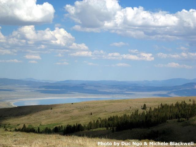
Map | View of Mono Lake from Cottonwood Canyon Rd.

Map | View of Mono Lake from Cottonwood Canyon Rd.

Map | View of Mono Lake from Cottonwood Canyon Rd.

Map | View of Mono Lake from Cottonwood Canyon Rd.

Map | View of Mono Lake from Cottonwood Canyon Rd. - we turned around here and took Goat Ranch Cutoff to Hwy 395.

Map | View of Mono Lake from Pole Linde Rd - Duc & Michele took this road rather than Goat Ranch Cutoff

Map | Burcham Flat Rd - Theresa coming up the grade

Map | Burcham Flat Rd - Michele coming up the grade

Map | Burcham Flat Rd - Michele, Theresa, Doug (l to r)
Map | Burcham Flat Rd - Theresa, Michele, Duc (l to r) talking over something

Map | Burcham Flat Rd - Theresa, Michele, Duc (f to r)

Map | Burcham Flat Rd

Map | Burcham Flat Rd - Doug coming up the grade

Map | Burcham Flat Rd - Theresa coming up the grade

Map | Burcham Flat Rd - Michele coming up the grade

Map | Burcham Flat Rd

Map | Burcham Flat Rd - overlooking Hwy 395

Map | Burcham Flat Rd

Map | Burcham Flat Rd

Map | Burcham Flat Rd - Doug, overlooking Hwy 395

Map | Burcham Flat Rd - Duc

Map | Burcham Flat Rd - overlooking Hwy 395

Map | Burcham Flat Rd - Doug, Theresa, Michele (l to r)

Map | Burcham Flat Rd - Theresa (l), Michele (r) Clutch hands get tired!

Map | Burcham Flat Rd - and then ....... Doug, Theresa, Michele ()l to r)

Map | Burcham Flat Rd

Map | One of the Virginia Lakes south of Bridgeport - nearly 10,000 ft in elevation

Map | Virginia Lakes parking lot - Doug (l) with a couple of unknown riders.

Map | Virginia Lakes parking lot - Theresa (l), Duc (m), Doug (r) with unknown rider.

Map | Spur off Dunderberg Meadows Rd - we could see Mono Lake south and Bridgeport Reservoir in same scene. Theresa(lf), Michele (lr), Duc (r)

Map | Spur off Dunderberg Meadows Rd - we could see Mono Lake south and Bridgeport Reservoir in same scene. Theresa

Map | Spur off Dunderberg Meadows Rd - we could see Mono Lake south and Bridgeport Reservoir in same scene. Michele

Map | Spur off Dunderberg Meadows Rd - we could see Mono Lake south and Bridgeport Reservoir in same scene. Mono Lake, right. Doug

Map | Spur off Dunderberg Meadows Rd - we could see Mono Lake south and Bridgeport Reservoir in same scene. Bridgeport Reservoir is top right. Doug

Map | Spur off Dunderberg Meadows Rd - we could see Mono Lake south and Bridgeport Reservoir in same scene. Mono Lake in background. Duc

Map | Spur off Dunderberg Meadows Rd - we could see Mono Lake south and Bridgeport Reservoir in same scene. Mono Lake in background. Duc and Michele
Map | Spur off Dunderberg Meadows Rd - we could see Mono Lake south and Bridgeport Reservoir in same scene. Mono Lake in background.

Map | Spur off Dunderberg Meadows Rd - we could see Mono Lake south and Bridgeport Reservoir in same scene. Mono Lake in background. Doug, Theresa, Michele, Duc (l to r)

Map | Dunderberg Meadows Rd - Theresa, Michele, Duc

Map | Dunderberg Meadows Rd - Theresa

Map | Dunderberg Meadows Rd - Michele

Map | Dunderberg Meadows Rd to Green Lakes Rd - detour down powerline acess road. Duc

Map | Dunderberg Meadows Rd to Green Lakes Rd - detour down powerline acess road. Doug (l), Duc (r)

Map | Dunderberg Meadows Rd to Green Lakes Rd - detour down powerline acess road. Michele

Map | Dunderberg Meadows Rd to Green Lakes Rd - detour down powerline acess road. Theresa (f), MIchele (m), Doug (r)

Map | Dunderberg Meadows Rd to Green Lakes Rd - detour down powerline acess road. Theresa (f), MIchele (m), Doug (r)

Map | Dunderberg Meadows Rd to Green Lakes Rd - detour down powerline acess road. MIchele

Map | Virginia Creek Settlement - this creek wasn't 100 feet from my tent and people were catching their limits every day.

Map | Virginia Creek Settlement - this creek wasn't 100 feet from my tent and people were catching their limits every day.

Map | Virginia Creek Settlement - this creek wasn't 100 feet from my tent and people were catching their limits every day.

Map | Bridgeport - gasoline is going for $3.71 in Sacramento. The previous day, gasoline here was $5.09 for Regular.